- honors senior double major in Urban & Regional Planning and Mathematics
- from Oxford, OH
- working on geographic information systems (GISci) certificate
- University Academic Scholar in Law & Public Policy
- worked in Miami's Geographic Analysis Center on both classroom and client-based projects
"While I've had a great experience in pretty much all my urban & regional planning and mathematics courses, there have also been unrelated courses that I enjoyed more than I'd expected."
Why Miami?
"I've grown up around Miami's campus my whole life, with both my parents working here as faculty. There never seemed to be a question to whether I'd enroll as a student here, but when I was admitted as both an Honors student and as a University Academic Scholar in Law and Public Policy, Miami was definitely the best choice.
"On top of that, out of coincidence, my first semester, most of my classes were entirely first year students, and some of us had multiple classes together, so it really helped me with the transition — even though I really didn't know many of them to begin with! It was just nice to be among familiar faces and make some new friends along the way."
Best Miami Experiences

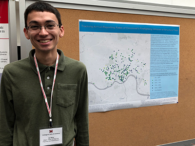
Ian Berg poses next to his poster ("Tracking Arrival-Reporting Rates of Cincinnati's Firefighting Vehicles at Structure Fires") at Miami's Undergraduate Research Forum
"Geography has always been interesting to me. In particular, I love creating and manipulating data in maps — not just things like topography but also maps that depict behavior, demographics, and other things. There are a lot of things you can do now with digital maps to make them more data-rich and interactive. Urban and regional planning (URP) was, at least for me, an ideal way for me to apply geography to a lot of real-world situations.
"Robbyn Abbitt, the coordinator for the Geographic Information Systems (GISci) Certificate Program in the Department of Geography, played a big factor in solidifying my decision to major in URP. She's also the associate director for the Geospatial Analysis Center (GAC), where I worked with her outside of class on contracts for the Butler County Board of Developmental Disabilities and Miami's Physical Facilities Department. And for her service-learning class I worked on an interesting project with the Cincinnati Fire Department and presented a poster in the fall.
"The GAC works on a variety of client-based projects, but I also helped assistant professor Amélie Davis update lab exercises for GEO 441 (Geographic Information Systems) after changes to the software used in class. She's also the advisor for my project on the various factors (demographic and environmental) that affect walking as a mode of commuting in Cincinnati, which I started last fall for my geography capstone. I've been continuing this project this semester for departmental honors.
"I've also always liked objectivity and making a lot of my own decisions, which is ideal not only for URP but also my second major in mathematics. During the summers of 2017 and 2018, I worked for the U.S. Department of Transportation (DoT) at a research center in Boston, mainly working on two different projects, both of which took advantage of my two majors."
Miami and the Liberal Arts

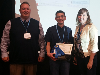
Ian Berg receives first place in the student category for his map presentation at Ohio GIS Conference (September 2018).
"I like that I've been able to take a broad range of courses at Miami. They don't necessarily all relate to one another, but they still make sense to me — there's definitely a reason why I chose certain classes over others. My two majors don't have a lot of overlapping requirements, but I'd say that they're both pretty flexible — so there's not a rigid track I have to follow, and I know I'm receiving a strong foundation that will give me a bunch of different directions I can go in for a career. Not having to follow any set path has made my choices more appealing to me; I've never been stuck in one area and could branch out as I needed to — that's a key aspect of the liberal arts that has been attractive for me.
Most of my URP electives are also part of the GISci certificate program, so they can involve a lot of data and analysis, but even my other classes can still be technical without being data-oriented — for example, I took Land Use, Law, and the State [GEO 467] last fall, and it would fall right into this category.
"Although much of my math coursework might not relate directly to urban planning, sometimes they intersect in surprising ways. For example, in a course called Graph Theory [MTH 438], taught by professor Tao Jiang, we discussed algorithms for finding the shortest path between two vertices, or connecting a set of vertices for the least cost. If you think of these vertices as destinations or cities, you can see how that would have planning applications. Overall, my math coursework has helped me look at problems in a geography or urban planning setting in a manner more oriented towards the ability to problem solve, and in helping me recognize that there are often multiple ways to solve a problem.
"While I've had a great experience in pretty much all my URP and mathematics courses, there have also been unrelated courses that I enjoyed more than I'd expected. One of these was an environmental biology class [BIO 121], taught by associate teaching professor of biology David Russell, which gave me interesting connections that I could make to the planning and geographic side of things, especially with respect to sustainability."
Working on Department of Transportation Projects
"During the summers of 2017 and 2018, I worked at a DoT research center in Boston. There I focused on a lot of literature review and data processing, primarily on two different projects.
"One of these projects was related to how we model traffic in a work zone (like road construction), and the other was about the impacts of vehicle and traffic automation, including self-driving technologies. Last summer in particular, I was focused on elements that reduce the driver's involvement and workload. I had to seek out findings of how low-level technologies in automation affect traffic flow, emissions, or fuel consumption, and then we put them together into a range of estimates. [See Systematic Review and Meta-Analysis of Adaptive Cruise Control Applications: Operational and Environmental Benefits.]
"Here's an example of a typical situation we had to analyze for my other major DoT project. If you're driving along with another driver in front of you, the way you follow that driver on a regular highway is different than the way you would follow that driver when there's something like a construction work zone, which requires you to be more alert. In terms of software systems that civil engineers use to plan these work zones, we examined whether there's a different model for driver behavior that works better in work zones than the default model for freeway driving. Engineers try to plan for traffic flows by creating simulations that are as accurate as possible, but there are many complicated factors to determine how these simulations come about." [See Validating the Performance of the FHWA Work Zone Model Version 1.0: A Case Study Along I-91 in Springfield, Massachusetts.]
Advice to Students
"I've lived most of my life around Oxford and was never really used to a lot of change before becoming a Miami student. Of course, things are different now that I've worked for two summers in Boston, helped out in the GAC, and had a variety of other experiences.
"Therefore, my main advice to new students, especially those who are like I was, is to not be too narrow — take on a broad range of courses and opportunities to discover what works for you."
[April 2019]
 Miami University Oxford, Ohio est. 1809
College of Arts and Science
 Miami University Oxford, Ohio est. 1809
College of Arts and Science