Move-in
These maps of each quad provide information about the entrances, exits, and parking areas for move-in day.
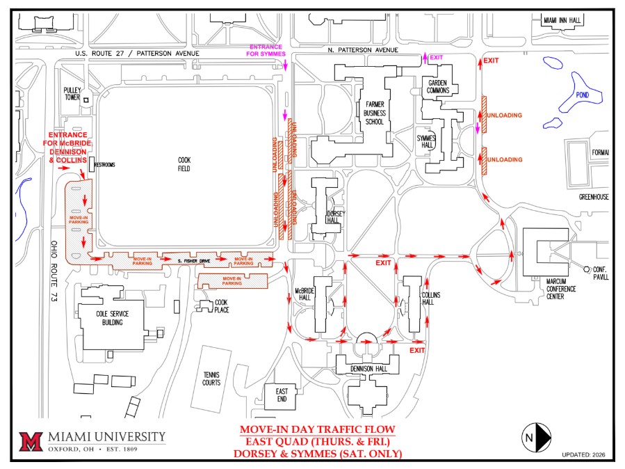
This map shows Route 73 on the left side and Patterson Avenue on the top of the map. Cook Field is in the upper left corner of the map. Students in McBride, Dennison and Collins Halls are encouraged to enter from Route 73 and follow the red arrows around the east side of Cook Field, turn right at McBride Hall, proceed into the quad in front of Dennison Hall, turn left in front of Collins Hall and exit the quad towards Marcum Conference Center and Symmes Hall. Students in Dorsey and Symmes Halls are encouraged to follow the purple arrows and enter East Quad near Farmer School of Business (FSB), proceed between Dorsey and FSB into the quad and proceed to Dorsey or Symmes and exit the quad near Garden Commons, past Marcum, and west back to Patterson.Students moving into Symmes Hall should enter from Patterson Avenue to the north side of Cook Field. The map is oriented horizontally with north pointing to the right of the map.
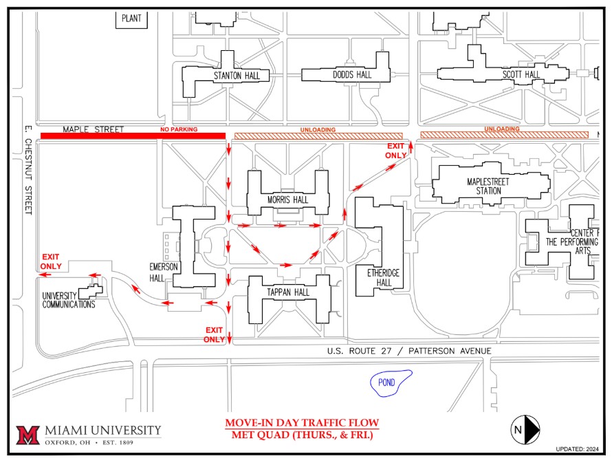
This map shows US Route 27 / Patterson Avenue at the bottom of the map, Chestnut Street on the left side of the map, and Maple Street at the top of the map. Morris, Emerson and Tappan students are directed to follow red arrows to enter the quad from Maple Street. All are directed to exit the quad on the slant sidewalk near Etheridge Hall or south of Emerson onto Chestnut Street. The Miami University logo is at the bottom left corner of the map. The map is oriented horizontally with North pointing to the right of the map.
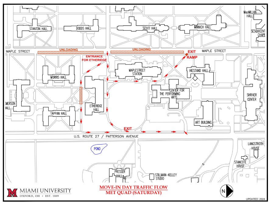
This map shows US Route 27 / Patterson Avenue at the bottom of the map, and Maple Street at the top of the map. Etheridge and Maplestreet Station students are directed to follow red arrows to enter the quad from Maple Street using the slant sidewalk. Etheridge traffic is directed to exit the quad on the sidewalk going north along US Route 27 / Patterson Avenue or go north on the sidewalk between Maplestreet Station and Center for the Performing Arts building coming back onto Maple Street. The Miami University logo is at the bottom left corner of the map. The map is oriented horizontally with North pointing to the right of the map.
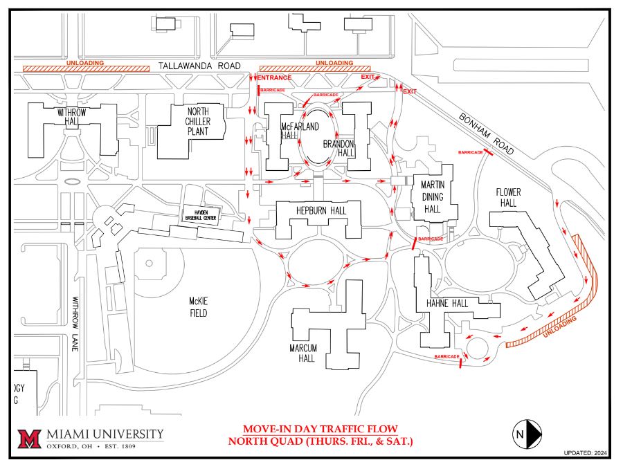
This map shows Tallawanda Road at the top of the map and Bonham Road on the right. There are unloading areas on the east side of Tallawanda Road in front of Withrow Hall. Traffic enters the quad from Tallawanda Road via the service drive heading east then north to either McFarland Hall or Brandon Hall. Traffic will leave that area of the quad by the slant walk to the north coming out at the stop sign area of Tallawanda Road and Bonham Road. Traffic enters the quad from Tallawanda Road via the service drive heading further east then turning north onto a sidewalk to Hepburn Hall. Traffic will leave that area of the quad by going north to another service drive near Martin Dining Hall. Traffic enters the quad from Tallawanda Road via the service drive then onto a sidewalk heading further east then north to Marcum Hall. Traffic for Flower Hall and Hahne Hall will use the service drive on the south-east side of Bonham Road. This is two-way traffic to the loop near Hahne Hall with an unloading area on the north-east side of the drive. The Miami University logo is at the bottom left corner of the map. The map is oriented horizontally with North pointing to the right of the map.
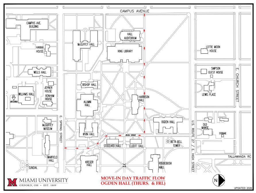
This map shows Academic Quad with E. Spring St. at the left side, Campus Ave. at the top of the map, and High St. at the right side of the map. Traffic for Ogden Hall should enter Irvin Dr. from E. Spring St. and proceed to make a left just before Ogden Hall for unloading. Traffic will then proceed west to exit the quad at Campus Ave. The Miami University logo is at the bottom left corner of the map. The map is oriented horizontally with North pointing to the right of the map.
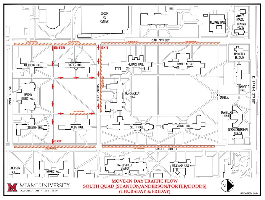
This map shows Maple Street at the bottom of the map, and Oak Street at the top of the map with Center Drive on the right and Harris Drive on the left. Traffic should enter the quad from Oak Street, following the red arrows through the quad to the unloading zone for Porter Hall or Dodds Hall. Traffic will follow the red arrows to the east to exit the quad onto Maple Street or north onto Center Drive to exit to the west to Oak Street.There are unloading zones for Stanton Hall and Dodds Hall on Maple Street as well as on Oak Street for Anderson Hall and Porter Hall. The Miami University logo is at the bottom left corner of the map. The map is oriented horizontally with North pointing to the right of the map.
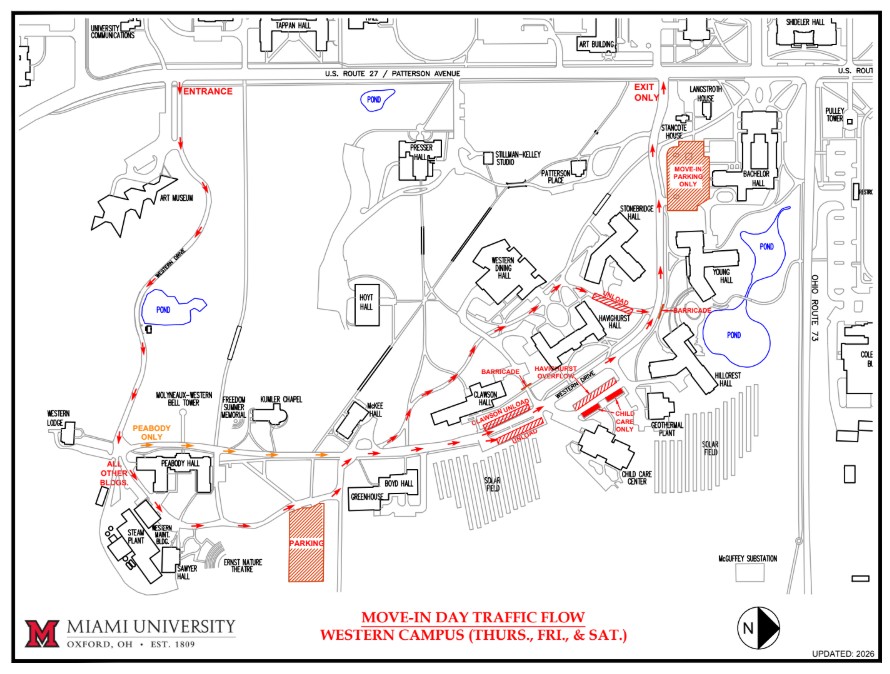
This map shows US Route 27 / Patterson Avenue at the top and Ohio Route 73 on the left of the map. Traffic will enter on Western Drive by the Art Museum. At Peabody Hall, traffic will split, with traffic for Peabody Hall only taking the first left turn (where it says "DO NOT ENTER") and going to the correct unloading zone. This traffic will then merge back with the other traffic continuing onto other halls. All other traffic will follow the drive behind Peabody Hall to other halls on Western Drive.
Traffic for Havighurst Hall can follow the slant sidewalk on the northside of Western Drive to the unloading zone on the north side of the building where traffic will exit the sidewalk back onto Western Drive to exit this area back onto US Route 27 / Patterson Avenue. An additional unloading zone for Havighurst overflow is available across the street from Havighurst Hall in the parking area directly across from the hall.
Traffic will continue on Western Drive to the north to the unloading zone on the street for Clawson Hall. An additional unloading zone will be available at the Thomson Hall parking area.
As traffic returns to US Route 27 / Patterson Avenue, a right turn towards the north, Cook Field / Ohio Route 73 is the only way to exit the area. The Miami University logo is at the bottom left corner of the map. The map is oriented horizontally with North pointing to the right of the map.
Office of Residence Life
211 Warfield Hall451 East Spring St.
Oxford, OH 45056 ResidenceLife@MiamiOH.edu 513-529-4000